August 31, 2015

Juggling routine

On the cruise so far, I’ve spent the majority of my time sampling and analyzing samples for the CO2 system parameters (pH, dissolved inorganic carbon (DIC) and alkalinity), along with sampling for dissolved organic carbon (DOC). Since I’ve been so busy with samples, writing these posts is taking longer than I had initially hoped. Because of that, it seems relevant to share what a typical day is like for me, now that I’m fully adjusted to my odd sleep schedule and excellent shift.

Shortly after my shift ends at 8 AM, I check the “Board of Lies” before going to bed so I know what to expect during my next shift. If there is a station while I’m sleeping, I organize bottles for Ryan to collect DOC samples for me so my sleep is not disturbed. Once I’ve organized my bottles I head to my stateroom, climb into my bunk, pull the curtains closed (all of the bunks have curtains), and am usually asleep before 11 AM. While sleeping in a twin bed on the top bunk in a shuddering icebreaker may not sound that great, I always sleep soundly in my small, yet cozy bed.


The image of the board of lies is updated every 2 minutes, however, the board itself is updated at most every hour. Since things are constantly changing at sea — especially in thick ice — the times on the board are often wrong (they are the chief scientist’s best estimates), which is how it earned its name, The Board of Lies.

After my good morning/afternoon’s sleep, my alarm wakes me up around 5:30 PM (I average 6-7 hours of sleep each day), and the first thing I do (before getting out of bed) is check if we’re on station by opening the ship’s CTD Cast Display from my phone. If we’re on station and the rosette is in the water, profiles of the CTD sensor data are displayed and I assess the amount of time before the rosette is back on deck and sampling begins.


Display of the CTD data while the rosette is in the water from my phone. The y-axis is depth in meters (ocean surface is at the top, and the ocean bottom is at the bottom). The red profile is temperature, blue is salinity (cut off on right) and yellow is oxygen, while the horizontal pink lines mark the depth that Niskin bottles have been closed as the rosette is brought back to the ship.

While the rosette is in the water, Ryan, Fen and I (whoever is on shift) organize sampling bottles and carry them (usually takes about five trips) to the hanger where we sample. Going back and forth to the hanger and van has resulted me walking an average of 4.7 miles and climbing 50 flights of stairs per day over the past week (according to Apple’s Health app). Once our bottles arranged in the hanger, one of us goes to the aft control room to add our bottle numbers to the sampling log before the rosette is brought back on deck and sampling begins.

Joseph (left) follows the CTD profile trace and closes bottles at the desired depths as the rosette is raised by the winch operator on the right (not sure of his name).
Once the CO2 system parameters have been sampled, we bring our bottles forward to the carbon van and prepare them for analysis. While CO2 samples get to temperature (20 or 25°C) and the instruments warm up, I run back to the hanger to collect DOC samples from the rosette. Once I’ve collected all of the DOC samples and have stowed them in the freezer, I head back to the van to juggle analyzing samples on four instruments simultaneously. Whether Ryan, Fen or I are in the van working solo or if we are overlapping, we are managing the collection and analysis of our samples incredibly well and keeping high spirits. Typically, seven people would be doing the amount of work we are accomplishing out here in the Arctic, and we are all proud of the beautiful data that is resulting from this cruise.

After all samples are analyzed or passed on to Ryan to finish during his shift, my shift ends at 8 AM, when I like to go on to the bow or up on the bridge to get a good look at the ice we’re making our way through, and also to chat with some of the Coast Guard who on bridge watch duty. If I’m not on the bow or bridge after my shift, I’m either in the conference room or computer lab writing a blog post, catching up on email or entering information into my DOC sample log spreadsheets before checking the Board of Lies before bed.

View from above the bridge, taken at 10:43 PM on Aug. 27 at station 26. Views similar to this, which are updated every hour, can be found on the sidebar to the right.
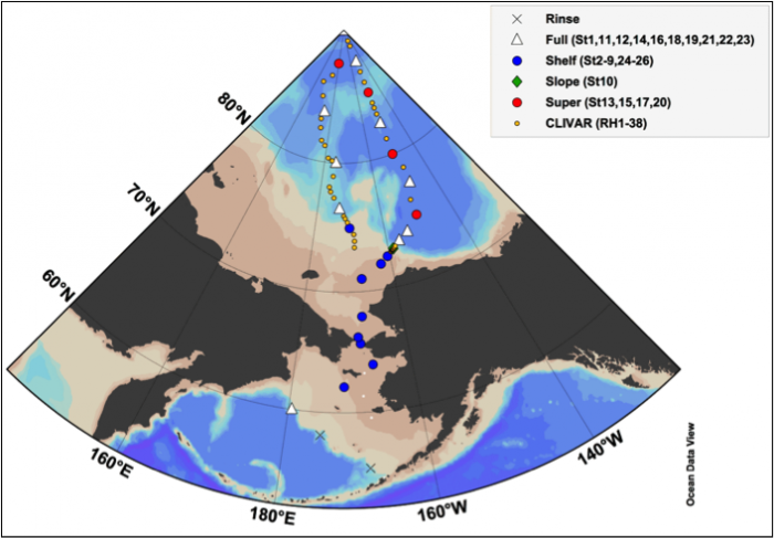
We just recently finished a line of 6 Repeat Hydrography (yellow dot) stations, and are now at station 26, which is a Full (white triangle) station located at 83° 44’N, 174°36’W (view station map here). We’ll probably be here for another day before we continue on, en route to the North Pole.


—AA

August 24, 2015

Shifty people

We’ve now been at sea for around two weeks, which means we’ve had that time to get used to our schedules (or for some of us, lack of schedules). Sampling and analysis at sea goes around the clock, with some people working opposite shifts (e.g., noon to midnight and midnight to noon) so there is always someone from each group working in the labs.

In the carbon group, our shifts are staggered so that at least one of us is available for sampling and analysis at all times – day or night. Our shifts are 12 hours long, but the shifts sometimes begin early or end late if we happen to be backlogged and are continuing to sample (sampling never ends on this cruise). My shift begins at 8 in the evening and ends at 8 in the morning, which is the shift that I elected to take. You might think I’m crazy for choosing that shift, but there are a number of reasons why I think it’s the best shift.

1) Breakfast (served from 6:45-7:45, 7-8 on Sundays).

Over the past couple years, I’ve debated with many people about which shift is the best, and for me, breakfast is where it’s at. I’ve heard the argument that breakfast is always the same, but breakfast is always great, so I have no problem with having something consistently great. Working a shift that skips breakfast but includes lunch and dinner means you get more variety (like tasty burgers, fish tacos and salad while it lasts), but while those meals are oftentimes a hit, they have the most potential to be a miss. Breakfast on the other hand, is always amazing. For me, there’s nothing better than stepping out of the carbon van at 6 in the morning and catching a whiff of bacon and eggs being cooked in the galley. In addition to that smell telling me that breakfast is right around the corning, it tells me that my shift is almost over, and to me, there’s nothing better than that.

2) Sunrise and sunset (taken at 12:16 AM).
I also get sunrise and sunset during my shift, which is undeniably great. On August 15th, I caught the sun rising over Nome, Alaska, and just yesterday on the 19th I got to watch the sunset morph into a sunrise over about five hours during my shift (pictured above).

3) Wildlife (like this polar bear from a distance).
I think that animals tend to be most active at dawn and dusk, so I also get to see the Arctic wildlife (but I think everyone on board will get the chance to see a variety of animals during this cruise). I briefly saw a humpback whale towards the end of the first cast of the first station on Aug. 12th, walruses welcoming us to the marginal ice zone on Aug. 18th, and late on the 19th I saw a polar bear from a distance (while others saw two).

We are currently at the second Full station of the cruise (first in the Arctic at 76.5°N, 173°W), and will be continuing northward to some CLIVAR Repeat Hydrography stations later in the day (view station map from And so it begins for reference).

Well that’s it for this week! I’ll try to write one science/cruise post and a life at sea post for you next week! More photos and great stories to come!


—AA

August 18, 2015

A turn in the left direction

At the beginning of the cruise, our Chief Scientist made it known that the sea ice in the Beaufort Sea/Canadian Basin had shifted, becoming thicker, which could affect our northward cruise track. One option given was to stick to the original route that goes northward through the Canadian Basin, returning south on the more western route (a counterclockwise track, following the map from About the Cruise). The alternative option was to do this portion of the cruise backwards (a clockwise track instead), which as it turns out, is what we’ll be doing.

During the science meeting on our first day aboard the Healy, the Coast Guard made it clear that if we went northward on the more eastern route, we may have to turn around before reaching the Pole since breaking through so much thick ice would consume too much fuel and time. On that same day (the 9th), our Chief Scientist stated that the final decision on the northward route would be made once we’ve arrived at station 7 (blue shelf station just north of 70°N, found on map in And so it begins), which we passed yesterday (the 17th).

Screenshot from my computer with the Healy’s science map server open, with an overlay of sea ice analysis from the National Ice Center (NIC) from the 17th. Our cruise track so far is marked by the red lines, and the Healy’s location as I write this is marked by a red dot and boat outline. To see our current location as you read this, click here.
If we had gone east to the Canadian Basin, we would be in thick ice for a longer period of time during the cruise, which would have cost us in fuel, time and sampling.
Prior to arriving at station 7, the seas picked up and were a little too rough for us to sample the intermediate Chukchi shelf station, so we steamed passed it in a north-northwestern direction. If we would have stopped to sample at station 7, sampling would have taken longer (harder to prepare, deploy and recover instruments when it’s rough out), and sampling would have been limited. Our hope now is that we can sample at that location in October if there is still time.

View from the Healy’s webcam above the bridge in the early afternoon of the 17th, when the old station 7 would have occurred. Small waves are pictured, crashing into the bow of the ship, making sea spray.
We are currently about three hours from the new station 7, which will be the first of thirty-eight Repeat Hydrography stations (or CLIVAR stations on map in And so it begins). The current latitude is 72° 55.476’ N, meaning that we’re north of the Arctic Circle, and in the Northern Domain of the Polar Bear.

Next post will be on our schedules at sea! I have some exciting photos to share, so stay tuned!


—AA

August 13, 2015

And so it begins

We arrived at our first station at around 7 o’clock in the morning on the 8th, and the approximate location can be seen in the first image as the white triangle at about 60°N and 180°E, near the Russian/U.S. economic exclusion zone (EEZ) boundary (in U.S. waters). On our transit to station 1, we had two rinse (or practice) stations, which are necessary for rinsing and testing the closing mechanisms of the Niskin bottles, and ensuring that our sampling procedures are efficient and our instruments are working properly.

Station map planned for the 2015 U.S. GEOTRACES Arctic Expedition (Kadko, 2015).
At most stations during this cruise, we will be deploying rosettes equipped with either 12, 24 or 36 Niskin bottles to sample multiple depths throughout the water column (from bottom to top), illustrated by this animation and introduced in About the Cruise. Typically there are multiple casts at individual stations, either because there aren’t enough bottles in the rosette to resolve the full water column, or because multiple rosettes are necessary for our sampling requirements.

For the first cast of station 1, we deployed a special 24-bottle rosette, designed to prevent contamination from the ship (made of iron), so low concentrations of elements (i.e., trace elements) such as iron can be accurately sampled. Once we recovered the rosette, it was sampled by the GEOTRACES teams, who will later determine the concentrations of various trace elements in special laboratories at their home institutes.

Shortly after the recovery of the GEOTRACES rosette, a large-volume rosette, equipped with twelve 30 L bottles, was deployed using the A-frame on the starboard (right) side of the ship, which was deployed to a maximum depth of 740 m (or about 2440 feet). Casts usually take about 1 hour for every 1000 m, so after about 45 minutes the rosette was on deck and sampling began. Ryan and Fen sampled all Niskin bottles, which we have since analyzed for pH and total alkalinity (TA), and dissolved inorganic carbon (DIC) in the carbon van. While they sampled for those three parameters, I waited my turn to sample for dissolved organic carbon (DOC), which I have since preserved by placing samples in the freezer. Once the cruise is over and the Healy has returned to Seattle in November, coolers filled with frozen DOC samples will be shipped to Miami, where they will be analyzed at University of Miami’s Rosenstiel School of Marine and Atmospheric Science, where I am currently pursuing my PhD.

The large-volume rosette being deployed at station 1. Notice how the bottle caps (top and bottom) are held open by the spring-loaded lanyards. Once the maximum depth was reached, bottles were triggered to close at the desired depths, collecting our seawater samples. The instrument package under the bottles is the CTD sensor package.
I had hoped to write this post on the carbon van and some of our instruments, however, I thought it would be best to write about our first station. Ryan, Fen and I are just starting to get settled in the van, and now that the first station is behind us, we are getting a sense for the rhythm of our sampling and analysis procedures. Once we get that rhythm down, I will write a post about the work we are doing in the carbon van and the CO2 system in seawater.

How does our lab van look compared to in June when we were in Seattle? The instrument on the left analyzes samples for pH, while the instrument on the right analyzes for TA (second TA instrument in partial view on the left).
This is my last post for the week, so expect a new post either Monday or Tuesday next week. As I write this, all sampling at station 1 is complete and we are now steaming to station 2 to begin our shelf sampling stations.

—AA

August 11, 2015

A fond farewell

On the morning of the 9th, after having moved onto the Healy the night before, all of us cruise participants woke up in our cozy staterooms to make final preparations to leave port and begin the 2015 U.S. GEOTRACES Arctic Expedition at 1 pm. For the most part, final preparations consisted of organizing and securing our lab spaces, along with securing our bulky science gear that we had to store in the holds. The holds were secured by 1 and most everything in the labs was tied down, so we all went to the forward 02 deck (the deck that directly overlooks the bow) to watch the Coast Guard crew members pull in the ropes before the Healy was tugged away from the dock by two small tugboats. Embarking on long research cruises like this one is always exciting, and it was great to celebrate with so many faces that are just beginning to become familiar. I look forward to getting to know the cruise participants, and I know that this is just the beginning of many great memories to come.

Some of us who gathered on the forward 02 deck to celebrate the beginning of this great cruise.
 After our celebrations, we went to the conference room for the general orientation meeting, where members of the Coast Guard that we’ll be working with introduced themselves and briefed us on their roles on the vessel. Following the Coast Guard introductions, the cruise chief scientist, Dave Kadko, gave us an overview of the science plan for the cruise, noting the ice conditions and the schedule for the next few days.

Dave sharing the current ice conditions and discussing the science plan with the science party and Coast Guard. Captain Jason Hamilton can be seen sitting to the right of the white board.
Following the meeting, we had abandon ship and man overboard drills (typical for the first day of research cruises), which are always an interesting ways to get to know each other and to get to know the ship.

Trying on our survival suits in the helo hanger.
After having our science meetings and safety drills, all 145 of us (51 are scientists) were ready for a tasty dinner (with salad while it lasts!), and were prepared to spend two months at sea.

One of our last views of land as we left the waters of Unalaska and entered the Bering Sea.
My next post will be on the carbon van, which Ryan, Fen and I have organized beautifully!

—AA

August 8, 2015

A little closer to home

After spending a week in Alaska, Ryan and I met up with Fen in Anchorage on August 3rd, and the three of us (and other cruise participants) flew to Dutch Harbor, Unalaska, AK on the 4th. We flew in a Saab 340B aircraft, which is a fairly small plane, only having room for 30 passengers. To share what our flight was like, I placed a camera in a window, taking one photo every 30 seconds during the 3-hour flight.

Our flight to Dutch Harbor on 8/4/15, before beginning the 2015 U.S. GEOTRACES Arctic Expedition.

When we landed in Dutch, the first thing I noticed was that we were surrounded by beautiful rocky green hills and small mountains, which surprised me since the last thing I expected was to describe this place as beautiful. In addition to being surrounded by the hills, bald eagles are everywhere on the island, which are commonly spotted soaring in the sky or perched on top of buildings and light posts. Another treat on the island is wild salmonberries, which grow on a roadside hill that we pass on our walk to and from the Healy each day, and this morning I picked a handful to munch on as I walked towards the port.

A bald eagle on a light post.
Wild salmonberries make a tasty morning snack!
View of the port. The Healy can be seen on the right, and a sign for it can be seen on the hill to the left.
Aboard the Healy, everyone is busy setting up their lab spaces, which you’re already familiar with from my first post, Resting Easier. One new thing that recently happened is that berthing has been assigned, which excites me since the Healy is finally starting to feel a little more like home. We aren’t allowed to move into our rooms yet, but I managed to take a sneak peak of my stateroom to get an idea of what my living situation is going to be like over the next couple months. Since I have two roommates and are shifts are unlikely to overlap (I know Ryan and I will overlap by 4 hours), it’s unlikely that I will spend time in my room besides the time that I sleep because when I’m awake, my roommates will likely be sleeping.

The door to Ryan’s, Steve’s and my stateroom.
A desk and the beds in our stateroom. It looks like I'll be sleeping on the top bunk!
Our stateroom is much bigger than I expected. A second desk, a television (for monitoring deck/winch operations and station arrival), filing cabinets (for clothes?) and a sink.
I’d love to write more about Dutch Harbor and the Healy so far, but time (and the internet connection -- this) is limited on the island before the cruise, so I’m going to stop here. I hope you enjoy my writing and my photos! My next post will be from the Bering Sea! I hope you look forward to it as much as I do!

—AA